mapping for recreation
About the project
Sports and recreation opportunities are crucial for the well-being of youth, yet there are multiple barriers to equal presence in outdoor activity landscapes, such as accessibility and inclusion. For refugee and temporarily displaced children and youth, additional barriers can relate to the inability to explore their new environments without the supervision of adults, and to the lack of knowledge of accepted social behavior and affordances offered by public space.
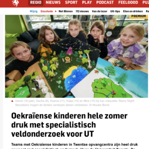
74 participants from Almelo, Boekelo, Vriezenveen, Oldenzaal, Holten, Tubbergen
explored and mapped 101 public places for sports and recreation using the EpiCollect application to enter observations on possible activities, perceived place safety and attractiveness, together with sensor- based measurements (e.g., temperature); made maps, designed inclusive recreation spots and presented their findings through map and art at the University of Twente.
Project Goals
understand how temporarily displaced youths perceive and use public spaces for recreation
- investigate cognitive, linguistics, and emotive facets of place among templorarily displaced youth
- provide space for participants to restore of basic needs such as sociality and safety
- provide participants with an opportunity to acquire skills in working with geospatial tools and data, as well as transferable skills related to sustainability, leadership, and teamwork
- raise awareness about current societal challenges and create a scaffolding for an international network of environmentally oriented future citizens
Current Outputs
Egorova, Ekaterina, Miller, Kateryna, and Rachel Pateman.“Place-based Citizen Science with Refugee Youth” (pp. 1–27). Zenodo, 2024. link
Data
“When we cycled around during this project, we got to see a lot of places, and I can now more or less self-orient in the city...and find my way home.”
“Water Rangers” (2022) project participant

